
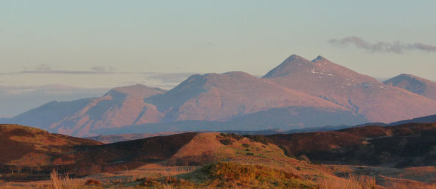
Beinn Cruachan Group
These pages sponsored by R&S Distribution, Top Flat, 6 Soroba Road, Oban PA 34 4NW
We are grateful to Iain R. White and and Irvine Butterfield for giving permission to reproduce this material.
Beinn Cruachan 3695ft / 1126m
Stob Dearg 3611ft / 1101m
Meall Cuanail 3004ft / 916m
Drochaid Glas 3312ft / 1009m
Stob Daimh 3272ft / 997m
Sròn an Isean 3163ft / 964m
Stob Garbh 3215ft / 980m
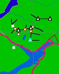 Black triangle = Munro, hill over 3,000 feet considered as a separate hill
Beinn Cruachan commands respect, for the traverse of its seven tops, with ascent of 4900 feet, is one of the classic expeditions of the Southern Highlands. The traditional start lies near the old railway station at Falls of Cruachan. A poor path leads up the west bank of the Allt Cruachan, passing through woods of oak, hazel and birch to reach the access road to Cruachan dam. This can be followed to the reservoir's western shore for the lower slopes of Meall Cuanail, the first summit of the west-to-east round. This is seen as a prominent rounded undulation on a broad ridge due south of the main summit. Many prefer to do the round from east-to-west, however, to enjoy longer the views to Loch Linnhe and the Firth of Lorn.
The Eastern Tops
From the dam, follow the reservoir's eastern shore, before beginning the gradual ascent of the grassy embankments to a bealach and thence to Stob Garbh, a cairned top perched on the headwall of the mountain's eastern coire, Coire Creachainn. The traverse continues to the north of this peak, across a short dip of 250 feet to the cairn of Stob Daimh, the highest of the three peaks around the eastern coire. Those seeking only to traverse these tops may prefer the alternative approach from the Stronmilchan road, where a well-defined track, the route of an old lead-mine railway, runs along the base of the hill to Coire Ghlais. The streams in this hollow, and that of Coire Creachainn are crossed by bridges (not marked on Ordnance Survey maps) to gain the long spurs of Stob Garbh or Sròn an Isean. From Sròn an Isean, the climb to Stob Daimh is steep and uneven and in mist traverse in the reverse direction requires care, as the ridge line is difficult to detect.
Drochaid Glas
The next summit along the ridge, Drochaid Glas, lies directly above the basin of the reservoir and the headwalls of a northern coire. This can also bemuse, for beyond Stob Daimh a large boulder field is crossed to reach its rocky knob, which has no cairn. To add to the confusion, the summit lies slightly to the north of the main ridge line. In mist, careful navigation is required to regain the crest, particularly when traversing from west to east when it is better to leave the summit and retrace one's steps for about 20 yards, keeping to the south side of the hill as the turn to the east is made. This helps to avoid the possibility of making a false start down the narrow. precipitous arête which falls towards Glen Noe.
The Western Tops
To the west of Drochaid Glas, the crest of the ridge is narrower and boulder-strewn, with large blocks appearing on the steeper ground below the main summit, where there is an Ordnance Survey pillar.
The ridge continues to a saddle and the peak of Stob Dearg, often referred to as the 'Taynuilt peak'. When descending to this gap in trust, a move to the south should be made as if going to Meall Cuanail. Once clear of the larger stones a westerly bearing can be taken to reach the foot of Stob Dearg. This peak can also be reached on a direct ascent from the Pass of Brander. Above the western end of the pass, follow the Allt Cruiniche to open slopes below the col separating Stob Dearg from the hump of Meall nan Each to the west.
A return to the Stob Dearg - Beinn Cruachan bealach, with some re-ascent towards the latter's summit avoids the slabby face of Coire a' Bhachaill. An easy descent due south then finds the short rise to Meall Cuanail, and the softer grassed slopes beyond which, falling towards the Cruachan darn, speed the return to the road by the Allt Cruachan.
Irvine Butterfield
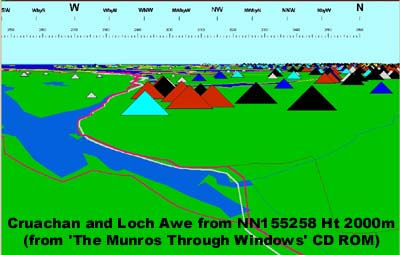
Routes in The High Mountains of Britain and Ireland are reproduced by kind permission of Irvine Butterfield. The Routes are provided from the PC CD-ROM The Munros through Windows by Iain R White which includes walks up every Munro and Top. Indeed it is the only publication to provide routes up every Munro and Top. Routes up the 3,000 foot hills in the British Isles furth of Scotland are also included.
 Black triangle = Munro, hill over 3,000 feet considered as a separate hill
Red triangle = Top, hill over 3,00 feet but not considered to be a separate hill
Cyan triangle = Corbett, hill 2,500 feet or over but under 3,000 feet having a drop of 500 feet all round
Blue triangle = Graham, Hill 2,000 feet or over but under 2,500 feet having a drop of 500 feet all round
Dark Blue triangle = hill which was once a Munro or Top but now is not
Grey triangle = a hill not falling into any of the above categories
